Day 2 in Rocky Mountain National Park

Hey Guys!

I hope you all had a wonderful holiday season!

We had a very busy end of the year…. with the holidays, moving our daughter and traveling to FL the day after Christmas,  it was a bit stressful to say the least ….so, I’m glad to finally see things slow down so I can get back into a routine!

So, let’s get started on Day 2 in RMNP!

Read Day 1 here

Before our trip to RMNP, I had read about a place called Cinnamon’s Bakery.

Since my hubby and I LOVE cinnamon rolls, I knew I had to add it to the itinerary!

I read that the tiny bakery would quickly sell out of their delicious cinnamon rolls so it was important to arrive early!

The bakery opened at 7:30 am so we arrived around 7:15 and there was already a line of about 10 people!

The owners opened the doors early and we quickly made it to the front of the line.

Thankfully, they had plenty left when we got to the counter to order!

We ordered a 1/2 dozen cinnamon rolls ($3.50 ea) & 1 pecan sticky bun ($4.50 ea) & 3 coffees ($3 ea).

We then took them back to the hotel and quickly started enjoying our goodies!

However, I was very disappointed ….they were really hard and just didn’t seem fresh. I’ve definitely had much better cinnamon rolls!

After we ate, we headed out to start our day in the park.

Shortly after entering the park, we spotted 2 huge mule deer!

After taking a few pics, we continued our drive to our first stop, the Alluvial Fan.

The drive into the park is so beautiful!

The Alluvial Fan is a fan-shaped area of disturbance that was created on July 15, 1982, when the Lawn Lake Dam above the area gave way, flooding the Park and the nearby town of Estes Park with more than 200 million gallons of water.

Enormous boulders were displaced, and trees and earth were ripped from the ground killing 3 people that were camping in the park.

Once we arrived to the parking area, we walked the short trail to the fan.

The trail is a 0.7 mile out and back that also features a waterfall and is good for all skill levels.

It was amazing to see these huge boulders that were moved by the rushing waters of the dam so many years earlier.

We visited the area for about 20-30 mins and then headed to our next stop, the Old Fall River Road.

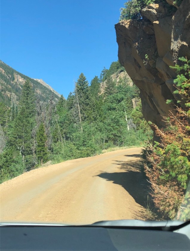
The Old Fall River Road is the first auto route in Rocky Mountain National Park offering access to the park’s high country and linked the east side of the park near Estes Park with Grand Lake on the west side.

The road is a combination of gravel and dirt. It’s one-way uphill and punctuated by switchbacks & is 11 miles long. The road leads travelers to Fall River Pass, 11,796 feet above sea level.

The posted speed limit is 15 miles per hour, a clear indication that a journey up Old Fall River Road is not for the impatient.

Getting ready to enter the Fall River Rd….

Thankfully, there wasn’t a lot of traffic on the road so we never felt rushed.

The drive was beautiful and one of the highlights of our trip! I highly recommend this drive if visiting the park.

I never felt scared on this drive even though there were no guardrails….there was plenty of  room without being too close to the edge.

The views were truly spectacular!

We stopped off at Chasm Falls

There is a parking area at the falls if you want to take the short, steep walk to the bottom of the falls. The falls are about 30 ft high.

After this short stop, we continued our drive while I continued taking hundreds of pics!

We saw several marmots during our drive!

Read here about the different kinds of animals that are found in the park

We passed the Chapin Pass trailhead

As we continued our drive, we got closer and closer to the Alpine Visitor Center…that’s where the road ends and then puts you back on the main road through the park.

Right before we arrived to the visitor center, we pulled over at small parking area and got out and took some pics.

We then continued our drive to the Visitor’s Center…once we arrived, we decided to stop for lunch. This time we finally found a parking space but it was still super busy!!

The visitor center is more than 2 miles above sea level! There is no utility or phone lines that connect it to the outside world. A diesel generator supplies power.

Each day sewage is hauled away by a sewage truck and they get their water from a dam that sits below the visitor center that collects snow melt which is then treated and stored nearby!

The logs on the roof protect the roof from sustaining wind damage as winter winds can gust to over 150 mph! The elevation is 11,796 ft.

The poles surrounding the visitors center serve as markers so in the spring plow drivers know where the roads and buildings are as snow drifts as high as 20+ feet are not uncommon.

The views from the visitor center were incredible!

Shots from inside the visitors center

We then headed to the gift shop to look for a few souvenirs….

After walking around the different displays in the center & purchasing our souvenirs, we headed to find some food.

They offered a few hot and cold items….we opted for 3 pre made sandwiches ..they were $10 each!

As we were leaving, I spotted some of my favorite candy so I had to purchase a few before we left…I love Hammond’s candy! They are actually based in Denver and opened in 1920.

After we ate, we left the visitor’s center and headed to our next stop, Bear Lake.

Look at all the cars trying to get into the parking lot!!

We didn’t make any stops along the way, as we had already seen this part of the park so I just snapped pics as we were driving.

I couldn’t stop taking pictures of the breathtaking views!

We finally arrived to our next stop, Bear Lake.

This is one of the busiest areas of the park! When we tried to visit this area during our first day in the park, we were turned away by park rangers because it was too full.

UPDATE: You can either get a reservation for the entire park including Bear Lake Road for 5 a.m. to 6 p.m., or the park with no Bear Lake Road access from 9 a.m. to 2 p.m. Outside of these peak hours, you do not need a reservation. Click here & here for reservations.

Thankfully, we were able to get in this time but we had to take a shuttle to the trailhead.

On this trail, you can hike to several lakes…some of those being Bear,  Nymph,  Dream, and Emerald.

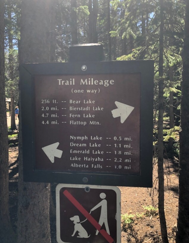
Click here for hikes in the park and here & here to read about the waterfalls in the park.

We first hiked the short trail to Bear Lake…this is one of the most popular trails in Rocky Mountain National Park, year round.

Frequent benches and resting places are provided, with lots of opportunities for peak views.

As usual, I took way too many pics!

We spotted a snake in the water!

We then headed to the next lake, Nymph.  We had to backtrack on the trail and head the other direction to get to Nymph Lake.

It was only 1/2 mi hike to the lake …

This lake was beautiful!

Waterlilies graced the surface of this deep blue lake, and Longs Peak, Flattop Mountain and Hallett Peak rise above it.

From Nymph Lake, we continued on another 0.6 miles to Dream Lake.

The views were stunning!

We passed a small waterfall on the trail

And crossed two small “bridges”

And then we were graced with this beauty!

Dream Lake was named for its dreamlike qualities; the way it reflects its surroundings like a mirror image, and how it looks different from every outlook.

I took wayyy too many pics here!

The water was so clear you could see the fish swimming in the lake!

You can hike another 0.7 miles from here to Emerald Lake but we decided to turn around and head back.

Tip: A 10 min drive from the Bear Lake Trailhead, you will find Sprague LakeMoose are often spotted here. It’s less than a mile round trip. Click here to read about where you can find Moose in the park.

We stopped several times on the way down to snap pics of the beautiful views

As we were exiting the park, we spotted the park’s sign so we had to stop and get our picture in front of the sign! You can’t visit a park and not have your picture made in front of the sign! 😉

Later that evening, we headed to find something to eat in Estes Park….this place was extremely crowded and it wasn’t easy trying to find parking!

After finally getting parked, we spotted Penelope’s Burgers & Fries….since my hubby is a huge burger fan, we decided to eat here..not to mention it was world famous & voted the #1 burger in Estes Park so how could we go wrong?! 😉

We had to order at the counter and then go find a table….

They offered a variety of options from beef, elk, buffalo and turkey burgers to french dips, patty melts, grilled chicken sandwiches, club sandwiches, etc….so they have plenty to choose from.

I decided on the french dip while my hubby and daughter ordered a burger.

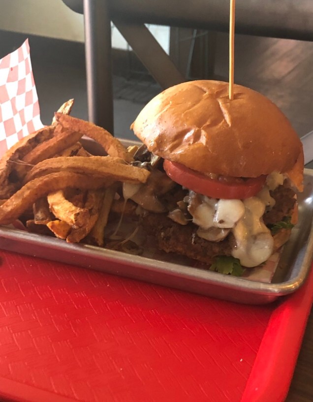
We also ordered the fried macaroni and cheese bites….yum!

My hubby and daughter liked their burgers but the french dip was very average….guess I should have ordered the burger!

After dinner, we called it a night!

Thanks for reading & I hope this helps you plan your own trip to Rocky Mountain National Park.

Click here for the 25 best things to do in Estes Park, here for the best restaurants and here for the best hotels.

Click here for campgrounds in the park & Click here & here for the best places to spot wildlife in the park

Read Day 1 here.


Day 1 in Rocky Mountain National Park

Hey Guys!

So, back in July of this year, me, my hubby & daughter visited RMNP for the first time.

We love visiting national parks! It’s one of our favorite things to do!

Put me in the mountains surrounded by lakes & I feel like I’m in heaven!

RMNP did not disappoint!

Tip: Click here for the 10 best things to do in the park

Read Day 2 of our time in the park here

There are four entrances into the park, three on the park’s east side and one on the west. To make the most of your time in the park, choose the entrance that will give you the best access to the sights you want to see and experience.

We stayed at the Alpine Trail Ridge Inn.

The hotel sits about 1-2 miles from the Beaver Meadows Entrance. 

The hotel was very reasonably priced and was super convenient to the park.

My only complaint about the hotel was, I had booked online through the hotel’s website a few months before arriving. A couple of weeks before our trip, the price went down around $30 a night so I called the hotel to see if they would honor the lower price & they wouldn’t.

At this point, I couldn’t cancel my reservation without being charged the full amount because they had a very strict cancellation policy….so, I was not a happy camper! I also had to email & call multiple times to get a response from them.

Read reviews here

Before arriving to Estes Park, we had stayed 2 nights at the Eldora Lodge in Golden. The lodge was about an hours drive from Denver.

We all LOVED this place!!

Read reviews here

After checking out of the Eldora Lodge, we headed to the park..

The drive from Eldora Lodge to the Beaver Meadows Entrance takes approx. 1.5 hrs.

On the way, we stopped at the Chapel on the Rock in Allenspark, CO….the chapel was 1 hr from Eldora Lodge & 25 mins to the park’s entrance.

Read reviews here

The chapel was over twenty years in the making before it was finally completed in 1936.

The serene and inspiring location was even visited by Pope John Paul II who came in 1993, prayed in the chapel, and blessed it afterwards.

After leaving the church, we continued our drive.

The drive to Estes Park was very scenic!

We passed the RMNP sign…the park was established in 1915.

Once we entered the park, we had to sit in a very long line to pay the entrance fee.

UPDATE: You are now required to have reservations to enter the park….For 2023, the reservation dates are May 26 through Oct. 22, 2023. You can either get a reservation for the entire park including Bear Lake Road for 5 a.m. to 6 p.m., or the park with no Bear Lake Road access from 9 a.m. to 2 p.m. Outside of these peak hours, you do not need a reservation. Read more here & Click here & here for reservations.

Tip: I did read that the Fall River Entrance is less crowded & more convenient to the Trail Ridge Rd & Old Fall River Rd. It’s only 10 mins from Estes Park.

There’s a one day pass you can purchase for $30 or a 7 day pass for $35. We chose the 7 day pass since we would be visiting the park for 2 days.

You can purchase the passes online here

Before leaving for our trip, I had purchased & downloaded the Gypsy Guide app for the park. I have used Gypsy Guide in other parks & loved it!

It didn’t disappoint for RMNP either!! Such a useful & helpful app!

Once we entered the park, we drove the Trail Ridge Rd through the park.

The Trail Ridge Road is the highest continuous auto road in the US..it travels 48 miles over Trail Ridge in Rocky Mountain National Park. The road runs above 12,000 feet for four miles and over 11,000 feet for 11 miles.

It climbs almost 5,000 vertical feet from Estes Park to its high point, traveling through three life zones that’s the equivalent of traveling from Colorado to the Arctic.

The many turnouts along the way provide scenic overlooks and tremendous photographic opportunities, day or night.

The road travels through forests, over the alpine tundra, reaches the high point, and crosses the Continental Divide before winding its way down to the town of Grand Lake.

There are numerous trails, short hikes and scenic pull-off spots. The drive can take anywhere from 2 hours of non-stop driving to an all day trip with scenic and meal stops.

There will be many well marked pull overs in the first 18 miles of the Trail Ridge Rd.

The first one we came to was Many Parks Curve Overlook…

Many Curves Overlook is a spectacular viewpoint…..the 9,620-foot overlook sits on a high wooded ridge above several open parks.

This was a busy stop & some of the views were obscured by the trees but beautiful nonetheless!

Read reviews here

After this stop, we continued our drive through the park….it’s a beautiful drive!

Our next stop was Rainbow Curve Overlook.. an 8 min drive from the last stop.

Rainbow Curve, enclosed by a low stone wall, sits on the outer edge of a wide switchback on Trail Ridge Road 12.8 miles from the Beaver Meadows Entrance Station.

This major viewpoint at 10,829 feet is just below timberline, the transition zone between a subalpine fir and spruce forest and the alpine tundra of grass and delicate wildflowers. The vista looks down on Horseshoe Park, an open grassy valley floored by twisting Fall River.

Tip: There are toilets & plenty of parking at this stop

Our next stop along the Trail Ridge Rd would be Forest Canyon Overlook — just a 6 min drive from the last stop.

The views on the way were spectacular!!

Forest Canyon Overlook offers some of Trail Ridge Road’s most dramatic views. The 11,716-foot viewpoint perches on the eastern edge of Forest Canyon, a deep U-shaped valley in the heart of Rocky Mountain National Park.

Glaciers chiseled out the deep canyon along a major fault line that the Big Thompson River now follows. The Continental Divide, the spine that separates the Atlantic and Pacific watersheds, hangs on the skyline across the valley.

It’s a short walk to the end of the viewpoint.

After this stop, we continued our drive….

We pulled out a bag of chips that we had in the car & they were about to explode due to the elevation!!

Our next stop was Rock Cut Overlook..…a 5 min drive from the last stop.

Rock Cut, a projecting rock formation at 12,110′ elevation, had to be cut through by road crews in order to allow the Trail Ridge Road to pass. The highly resistant rock was blasted away with large quantities of explosives;

Tip: There is a trail that you can hike at this stop called the Tundra Communities..it’s 1.1 mi r/trip…we didn’t hike it as the elevation was really getting to us.

This was a very crowded stop….& you will see why…the views were worth it!

I spotted this lake while I was snapping pics!

We saw lots of marmots running around!

Read about other animals you can see in the park here

We continued our drive through the park…

Our next stop was Lava Cliffs Overlook.…5 mins from the last stop.

According to the Trail Ridge Road guide, the dark cliff northwest of the parking area is composed of volcanic rock.

Glacial ice carved into the hillside exposed a cross section of the Precambrian Rock to form the lava cliff that you can see from the overlook today.

We saw lots of elk & marmots at this stop!

We left here & continued our drive to the Gore Range Overlook just 2 mins away from the last stop.

At 12,048 feet elevation, Gore Range Overlook offers spectacular, sweeping views of the Gorge Range, the Never Summer Mountains, and Rocky Mountain National Park’s highest peaks.

The overlook sits above the treeline in the alpine tundra, just down the road from the highest point on Trail Ridge Road (12,183 feet elevation).

The views were gorgeous!

We spotted a couple of small lakes from the overlook.

Next on the list was the Alpine Visitors Center just a 2 min drive from Gore Range..

Click here to see a list of the visitor centers in the park

Tip: There’s a 1/2 mi r/trip hike you can do at the visitor’s center…called the Alpine Ridge Trail. Click here for the 15 best hikes in the park

Sadly, this place was so crowded that we couldn’t even get into the parking lot! It was a mad house! I recommend you get here early…I think we arrived around 2 pm.

So, we continued our drive and stopped at Milner Pass. It was a 10 min drive from the visitor’s center.

At this stop you will see Milner Pass, Lake Poudre & the Continental Divide.

Milner Pass provides passage over the continental divide for Trail Ridge Road (US Highway 34) between Estes Park and Grand Lake.

Tip: There is a 6 mi r/trip hike here called Poudre River Trail & an 11 mi r/trip hike called  the Gorges Lake Trail

Don’t miss having your picture made in front of the Continental Divide sign!

After this stop, we headed to the Fairview Curve Overlook...just 5 mins from our last stop.

Farview Curve is a smaller scenic viewpoint than some of the other stops along the scenic highway, with little parking, but it’s sweeping mountain and valley views make it well worth the stop.

Once we arrived, the parking lot was full so we bypassed this stop & headed to Grand Lake...at this point you will be descending in elevation.

The drive to Grand Lake from Fairview Curve Overlook takes approx 30 mins.

Arriving into Grand Lake

After arriving into Grand Lake, we started looking for somewhere to eat lunch. We spotted Squeaky B’s.

Squeaky B’s mostly focuses on burgers and since my hubby is a burger connoisseur, we decided to give it a try.

The restaurant offers burgers, chicken sandwiches, salads, hot dogs & even breakfast.

I ordered the grilled chicken sandwich with sweet potato tots & my hubby & daughter ordered the burger & fries.

The food was very good! However, it was a bit expensive. The burgers cost around $10-13 each & fries weren’t included with that!

After lunch we decided to check out the lake.

Click here for the best things to do in Grand Lake

Grand Lake is the largest natural lake in Colorado. It was formed by glaciation many years ago. It has an estimated depth of 265 ft.

After leaving the lake, we decided to walk around the town. It’s a a really neat place!

Known as the “Western Gateway” to the Rocky Mountain National Park, Grand Lake has something for everyone.

Don’t miss taking a stroll down the historic boardwalk with over 60 shops, restaurants, and galleries, or take in a show at the new Rocky Mountain Repertory Theater.

We then decided we would do the short hike to Adams Falls. 

The hike is only .6 miles roundtrip but be sure to bring plenty of water…it was hot!!

On this same trail, you can also see Lone Pine Lake, Lake Verna, Spirit Lake & Boulder-Grand Pass.

The hike was a bit crowded and there were lots of adults with children on the trail.

I wasn’t overly impressed with the falls but if you want to see a waterfall, it’s nice enough & it’s a short hike.

Tip: Click here for more hiking trails in Grand Lake & here for hiking trails in Estes Park & here for waterfalls in the park

After the hike, we headed back into town to grab some ice cream before we left…

We came across Polly’s Sweet Shop & decided to stop.

They offered all kinds of options & flavors!

I ordered 2 scoops for $6.50…I had a scoop of the cookies & cream and a scoop of the cookie dough…it was delicious!

After leaving Grand Lake, we headed back to Estes Park though the park.

We stopped at a nearby trail that had views of open wetlands…the area was known for moose and I really wanted to see a moose!!

Sadly, after hiking about 1/2 mi, we never saw much of anything so we turned around and headed back to the car!

Tip: Click here for the 15 best hikes in the park

However, shortly after leaving the trail, we spotted a huge bull elk & 2 moose!!!

Click here for best places to spot moose in the park

We continued our drive & I took 3000 more pics on the way to our hotel!! 😉

The drive from Grand Lake to our hotel took approx 1 hr 45 mins.

We checked into our room (131) and it had been nicely remodeled.

After getting settled into our room, we headed out to find somewhere to eat…

We tried several places in/around Estes Park but everything was packed so we found a Mexican restaurant near our hotel called, La Cocina de Mama.

None of us were very impressed with the food & we thought it was really expensive!

We sat outside and had a nice view though! 🙂

Click here for the best restaurants in Estes Park, here for the best hotels & here for things to see/do.

Tip: The one place we tried to eat at a couple of times was Smokin’ Daves but it was always too crowded! It has over 4k reviews on Trip Advisor!

After dinner, we called it a night and headed back to our hotel!

Thanks for reading & stay tuned for Day 2!!

Click here for 15 Epic things to do in the park and all about the reservation system

Update: Read Day 2 here


A Day At Acadia Ntl Park

Hey Guys!

In 2016, my family and I spent our vacation in parts of Maine, Massachusetts & Rhode Island. Some of our time in Maine was spent at Acadia National Park.

This was my second visit here but my hubby & daughter’s first.

enhance

Acadia is a beautiful national park with 158 miles of hiking trails, 8 peaks above 1000 ft & 45 mi of carriage roads with 32 historic stone bridges.

The park encompasses 47,000 acres along the Atlantic Coast and has over 40 mi of ocean shoreline.

Some of the bridges we saw in the park enhanceenhance

Tip: To see two of the famed stone bridges in a little more than 5 miles, start near the southern end of Jordan Pond and follow the carriage road route called Amphitheater Loop, which hugs hillsides between two ridges to form a natural amphitheater.

Tip: Click here for the top 6 carriage road loop hikes & here for the 13 best things to do in the park

We loved the rocky beaches, the beautiful spruce & white birch trees and all the granite peaks such as Cadillac Mountain, the highest point on the United States’ East Coast.IMG_7797

Among the wildlife in the park are moose, bear, whales and seabirds. Acadia has hundreds of species of birds… the record for species of birds encountered is 338. The park is considered to be a premier bird-watching area.

Side note: If you see a bear or a moose in Acadia let me know as both are rarely seen in the park. 😉

The town of Bar Harbor, with lots of restaurants and shops, is nearby and a very popular place to visit.

The park is opened year round but is the busiest during the summer and Fall. The entrance fee is $30 per vehicle. There are over 2 million visitors to Acadia each year.

The park was first established as Sieur de Monts National Monument in 1916, then Lafayette National Park in 1919, and finally Acadia National Park in 1929.

Read more about the history of the park here.

There are a few apps that you can download that may help guide you through the park but this post should be super helpful with your planning!

You can first stop at the Visitors Center and pick up a map of the park. However, just so you know, the visitors center is located 52 steps uphill from the parking lot.

There is an entrance available through a back entrance for those with special access needs. Instead of turning into the parking area, go up the hill a short distance and find special parking next to the rear of the building.

At the visitors center you can also access one of the famous Carriage Roads & the 3.3 mi loop trail to Witch Hole’s Pond. (see map here) And, for those wanting to use the Free Island Explorer Shuttle Bus , it makes regular stops at the main parking lot.

You can also purchase your entrance fee at the visitors center as well as several other locations in/around the park.

enhance

The main drive in the park is called Park Loop Road. It’s a 27 mi road that begins at the Visitors Center. However, you can also access it off Route 3 just south of Bar Harbor on the right just past Jackson Lab.

Much of the road is one way but there is a two way section that begins near Wildwood Stables . Also, the right hand lane of the two way section is set aside for parking.

Click here to see a map of the park.

The first thing you will see when you begin your drive from the visitors center is Sieur de Monts Spring. This area includes the Wild Gardens of Acadia, the Abbe Museum and the Nature Center.

There are also some hiking trails in this area such as Jesup Trail. The Island Explorer Shuttle Bus has a pickup and drop-off point in the Nature Center parking lot.

The next stop would be the Precipice Trail. Read reviews here. I was a bit hesitant to even mention this trail in my blog as its been the site of several deaths in the park.

We didn’t do this trail and I wouldn’t recommend it to anyone who is not an experienced hiker…and even then I’m not sure I would recommend. Read about deaths in Acadia here.

The next stop is a “must see” and a very popular stop amongst visitors. It was one of my favorites. It’s called Sand Beach.


IMG_7825IMG_7814IMG_7802IMG_7822

The beach is the only “sand” beach in the park. It’s 870 ft long and nestled between two mountains. The ocean temps rarely exceed 55 degrees in the summer….so, if you’re like me and freeze all the time, I would avoid the water! 😉

No pets are allowed from May 15 – September 15. Changing rooms and restrooms are located next to the parking area. The Island Explorer Shuttle Bus stops there about every half hour during normal seasonal daytime hours.

There are a total of 3 beaches in Acadia. Sand Beach, Seal Harbor Public Beach and Echo Lake Beach. There are also two other less known beaches that are fairly close in Lamoine on the mainland.

The beaches in Lamoine State Park and Lamoine Beach are a couple of “secret” little places that most visitors know nothing about. They are much less touristy than Bar Harbor and Mount Desert Island and they have awesome views of Cadillac Mountain.

Here’s a shot of Seal Harbor Beach...it’s located at the Stanley Brook Entrance.

.enhance

enhanceenhance

There are two hikes that start near Sand beach. The Beehive Trail which is similar to the Precipice Trail but a bit shorter and the Great Head Trail, a loop of about 2 mi that follows the bluff overlooking the beach.

A shot of Beehive from Sand Beach. Beehive is a 520 ft peak that overlooks the beach.

enhance

At the far end of the upper parking lot at Sand Beach is the beginning of the popular 3 mi r/trip Ocean Path that follows along the coast for approximately 2 mi all the way to Otter Cliff and Otter Point.IMG_7832 IMG_7900

A hornet’s nest we spotted on the trailenhance

This is a great place to take some gorgeous shots of the rocky coastline that Maine is known for..this area was one of my favorites. IMG_7843IMG_7852IMG_7911

Part way in between is Thunder Hole where, when the tide and waves are just right, you can hear a sound like thunder as the waves crash into a small underwater cave. This is another popular spot and stays really busy!IMG_7862IMG_7879

If I can remember correctly, once you leave this area there’s a pull off near Otter Creek that has , what we thought, was a replica of an old fish house. Read the history of the fish houses here and here.

enhanceenhance

Next will be Jordan Pond and the Jordan Pond Restaurant…both a MUST when visiting the park. I would recommend you visit before or after the lunch rush as the parking here is very limited and stays super busy!

Jordan Pond is a glacier formed lake with a maximum depth of 150 ft. The water is super clear and has an average visibility depth of 46 feet. The lake is surrounded by big granite boulders and pine trees.

Swimming is not allowed but canoes and kayaks are permitted. The Carriage Roads are adjacent to the restaurant and pond area. IMG_7952Walking the path to Jordan Pond from the restaurant IMG_7933I had read all about the popovers at the Jordan Pond Restaurant and just had to try them…We all ordered the speciality beverage and popovers for $11.50.

You had a choice of 8 different drink options so I chose the blueberry lemonade….everything was so good! Highly recommend a stop here!IMG_7915IMG_7925A view of the pond from the table we were sitting at outsideIMG_7927The restaurant has been serving popovers and tea since the 1890s. The original building burned down in 1979 and a new building was completed in 1982.

Reservations, especially during lunch and the very busy teatime are highly recommended. If you can’t make a reservation, the shortest wait for tables are before 11:30am or after 4pm.

The restaurant is opened daily from 11-9. Reservations can be made by calling [207]276-3316 or online by clicking here. Click here for more restaurant information.

View of the back of the restaurant enhance

After leaving the restaurant, we headed to our next stop, Cadillac Mountain.

Tip: You are now required to have a reservation to drive Cadillac Summit Rd. The cost is $6 & the dates reservations are required are June 23 through Oct 22, 2023. Read more here & read here about tips on how to get the reservations.

Cadillac Mountain Summit Road is a 3 mile scenic drive to the top of the highest peak in Acadia National Park.

Cadillac Mountain is 1,530 feet tall & the highest point along the North Atlantic seaboard. It’s the first place to view the sunrise in the United States from October 7 through March 6.

So, needless to say, this is a very popular place to watch a sunrise and sunset. Come early as the parking lot fills up quickly and parking is limited.

Tip: Read here about the Cadillac Mountain Summit hike you can also do

The mountain offers some amazing panoramic views of many islands including both the Porcupine and Cranberry islands.

There’s a small gift, snack, and information center with bathroom facilities at the top called the Cadillac Summit CenterIMG_7766IMG_7741IMG_7755enhance

We never made it for a sunrise but we did make it back one evening for a sunset…however, turns out, the weather conditions were not optimal for a nice sunset….BUT the views alone made it worth the trip back to the top.

enhanceAfter leaving Cadillac Mountain, we headed to Bass Harbor Lighthouse.

The lighthouse was built of brick in 1858 and stands 56 feet above the water. The lighthouse is accessible by car off Route 102A. Parking is free and is open daily from 9:00 AM to sunset.

In July 2010, President Barack Obama became the first sitting president to visit Acadia National Park. He and his family spent three days in the park and paid a visit to Bass Harbor Head Lighthouse.

In November 2017, the Park Service took possession of the property. They are now looking at a few uses for the property that will generate revenue for the continued upkeep of the lighthouse.

They have considered such things as offering the two-bedroom lighthouse as a vacation rental or opening a café or coffee shop.

On the left side of the buildings is a 0.4 round trip trail that take you to a wooden stairway that follows down the front face of the cliff and eventually brings you to a prime spot for capturing a picture of the lighthouse and cliffs…this is also a great place to watch a sunset!IMG_7978IMG_7979IMG_7982

Read my blog post on all the Lighthouses that I have visited.

After leaving the lighthouse, we headed to find something to eat. We spotted a place called the Lighthouse Inn & Restaurant. The restaurant is located in Seal Harbor and is really your only option as we saw no other restaurants around.

The food and service was OK but when you’re hungry, it will do! IMG_7772IMG_7773

We all ordered a burger and they were pretty good…as you can see, we had a major mishap with the ketchup! 😉IMG_7774

After dinner, we headed back to our hotel and called it a day.

Please Note: Park Loop Road is closed annually December 1 through April 15.

Thanks for reading!

Click here to see links to all of my blog posts

Here are some other things to do/see in the park:

Little Hunter’s Beach – a small “beach” and private cove that is full of cobblestones – not suitable for swimming

Star Gazing – see the Milky way and millions of stars – click here on how to shoot the night skies in Acadia

Long Pond – in Seal Harbor near the Stanley Brook Entrance

The Abandoned Stone House – built in the mid 1800’s

The Gate Lodges – Built originally to keep automobiles off the carriage roads –Brown Mountain gate lodge is located on Route 198 outside Northeast Harbor. Its sister, Jordan Pond gate lodge, is just south of Jordan Pond House on the Loop Road. Both were built in 1931–32 by John D. Rockefeller Jr.

Below is a shot I took of the Jordan Pond Gate Lodge. Read more here.

enhance

Wildwood Stables – offers a variety of carriage rides and tours

Eagle Lake – a 436 acre freshwater lake in Acadia. It has a maximum depth of 110 feet and an average depth of 50 feet.

Pretty Marsh Picnic Area – picnic tables and grills – bathroom facility on the premises

Wild Gardens of Acadia – Over 300 native plant species organized into nine display areas and labeled for easy identification. The garden  is open year round & no entrance fee is required.

Seawall – known for its rocky shores and shallow tide pools where you may often see starfish and hermit crabs. The Seawall Campground is also located here.

Ship Harbor Trail – a 1.3 mile loop just east of the Bass Harbor Head Light Station – provides easy access at low tide with a surprising number of species including fish, reptiles, amphibians & invertebrates.

Baker Island -historical Gilley farm dating back 200 years – see the old granite dance floor or view and photograph the lighthouse – By boat tour from Bar Harbor

Bar Island – At low tide, the island becomes accessible by foot or by an all terrain type vehicle across a natural gravel land bridge.

A shot of us walking Bar Island at low tide

enhance

The Asticou Azalea Gardens – not part of Acadia but a beautiful Japanese style Garden  built in 1956 located on Mount Desert Island

Schoodic Peninsula – the secret place of Acadia

Eat Wild Blueberries  – they grow wild in the park and visitors can carry out two quarts of handpicked wild berries – They’re usually ripe around July

Mitchell Cove at Lopaus Point (see pics of the Cove from this rental house listed online)- secret spot

Camping in the park

Bike Rentals in the park

Schooner Head Overlook – and located right below the overlook is Anemone Cave. The cave was once one of the park’s most popular attractions but due to the dangers they have now removed it from the park map.  Only visit the cave during low tide and proceed with extreme caution as there has been drownings here.

Best Restaurants near Acadia Ntl Park

Compass Harbor Trail – a short walk that heads through the forested old estate to a granite outcropping that overlooks Compass Harbor and the Porcupine Islands in the distance. The ruins of the Old Farm estate are located on top of the hill above, although only the foundation remains.

Perpendicular Trail – a stair trail – Read reviews here.

Maple Spring Trail – 4.5 loop hike to the summit of Sargent’s Mountain

Waterfall Bridge is one of the more famous carriage-road bridges as its arch perfectly frames the beautiful Hadlock Falls (1.8 mi r/trip)

Hiking in Acadia. Click here for more trails & here for the 10 best hikes in the park

Take a boat from nearby Stonington to 5,400-acre Isle au Haut for a night at the Keeper’s House Inn, a working lighthouse. Hike the island’s rugged coast, then ride one of the inn’s bikes to Long Pond for a swim. See the Isle au Haut Lighthouse.

Take a ferry from Bar Harbor to Winter Harbor and then hop on an Island Explorer bus to make the Schoodic Loop – walk to the top of Schoodic Head for a sweeping  view of the coastline. Don’t miss Schoodic Point.

Rock climbing in Acadia

Things to do in Bar Harbor

Popular tours in Bar Harbor

Hotels near Acadia, hotels in Bar Harbor, restaurants in Bar Harbor, budget hotels near Bar Harbor & budget hotels near Acadia

Where to eat & picnic in Acadia

Thanks for reading! I hope this helps you plan your own trip to the beautiful Acadia National Park. 🙂