Hey guys!
I don’t know about you but I love photographing lighthouses. I think they are so beautiful and each one so unique. I also enjoy reading the interesting history behind them.
So, I thought I would do a post on some of the lighthouses that I have visited and photographed over the years. I’ll start with one that I’ve visited a couple of times, the Ponce de Leon Inlet Lighthouse.
I’m originally from FL and my Dad & Step mom still live there. They also own a condo on Daytona Beach so we have visited Daytona many times.
Ponce de Leon Lighthouse was completed in 1887 and is the tallest lighthouse in Fl and the 3rd tallest in the US stretching 175 feet into the sky. The tallest lighthouse in the US is Cape Hatteras Light in NC. It stands 207 ft tall.
Click here for a list of all lighthouses in the US & here for the lighthouses that are listed on the National Historic list.
There was actually a lighthouse built here in 1835 but was attacked by Indians in the Second Seminole War. The war prevented repairs to the lighthouse and it later collapsed.
The original lamp burned kerosene but in 1909 was replaced with an incandescent oil vapor lamp. The lighthouse beacon was electrified in 1933 with a 500-watt lamp.
It became a National Historic Landmark in 1998…one out of only 11 lighthouses to earn this designation.
See a list of US National Historic Landmarks by state here.
You can climb the lighthouse’s 203 steps to the top for some spectacular views. There is also a museum at the lighthouse.
The Lighthouse and Museum is open to the public seven days a week with the exception of Thanksgiving and Christmas.
Admission is $6.95 for adults and $1.95 for children (11 & under).
Infants (NB – 2) are admitted free of charge
Click here for more info on the lighthouse and read reviews here.
The next lighthouse is also in Fl…it’s the St. Augustine Lighthouse. The lighthouse was built in 1874 and stands 165 feet tall.
Construction began in 1871, and it continued for the next three years. Alabama brick and Philadelphia iron work combined with a new hand-blown, nine-foot-tall, Fresnel lens, from Paris, France was used in the construction.
This beacon was installed and lit in October of 1874 by head keeper William Russell and remains one of only a few such operating lenses in the United States.
A Spanish watchtower, built in the late 1500’s was the predecessor of the present St. Augustine Lighthouse.
The Lighthouse is St. Augustine’s oldest surviving brick structure, and today the site is restored to colors and materials used in 1888. In 1876, a brick light keeper’s house was added to the property.
Visitors can climb 219 steps up the historic lighthouse to see a breathtaking view of St. Augustine and the waters of the oldest continually occupied European port city in the continental United States.
At the top, the original, first order Fresnel lens still serves the beacon, but today is lit by a 1000 watt bulb. The St. Augustine lens consists of 370 hand-cut glass prisms arranged in a beehive shape towering twelve feet tall and six feet in diameter.
Admission is $12.95 for adults and $10.95 for children 12 & under. They also offer a ghost tour of the lighthouse for $24.95.
Read more history here and reviews here.
The next lighthouse is one of my favorites. I’ve visited it a couple of times. It’s the Portland Head Light in Portland, Maine.
The location of this lighthouse is what adds to its beauty. It sits along the rocky coastline of Ft. Williams Park. It’s one of the most photographed lighthouses in the US.
The construction of the lighthouse began in 1787 at the directive of George Washington, and was completed on January 10, 1791 using a fund of $1,500.
It was lit with 16 whale oil lamps.
It’s the oldest lighthouse in the state of Maine. The light station is automated, and the tower, beacon, and foghorn are maintained by the US Coast Guard. The former lighthouse keepers’ house is now a maritime museum.
The original plans had called for the tower to be 58 feet tall but when the masons completed the construction they climbed to the top of the tower and realized that it would not be visible beyond the headlands to the south, so it was raised approximately 20 feet.
The current keepers’ house was built in 1891. When Halfway Rock Light was built, Portland Head Light was considered less important and in 1883 the tower was shortened 20 feet and a weaker lens was added.
However, after mariners complained about the shortened lighthouse & weaker lens, the height and lens were restored back to it’s former height & lens in 1885.
The station has changed little except for the rebuilding of the whistle house in 1975 due to it being badly damaged in a storm. Today, the lighthouse stands 80 feet above ground and 101 feet above water.
The beacon is visible for 24 nautical miles. It has a 400 watt metal halide lamp that is rated for 20,000 hours and produces 36,000 lumens of light at 200,000 candlepower.
There is only one day each year when the Coast Guard allows a limited number of visitors inside the lighthouse: the annual Maine Open Lighthouse Day in September.
It was added to the National Register of Historic Places in 1973.
The Park is open year round from sunrise to sunset. Read reviews here.


The next lighthouse is outside of the US. It’s the California Lighthouse in Aruba. We visited this lighthouse when we visited Aruba for the first time in Nov 2017.
The lighthouse was constructed between 1914 & 1916 and stands 98 ft tall. It was named after the S.S. California, a wooden sailing ship that sank near shore in 1891.
The lighthouse keepers house has been turned into a restaurant called La Trattoria El Faro Blanco.
The lighthouse has completed a recent restoration in May 2016 which coincided with the 100th anniversary of the completion of the lighthouse.
There are several tours that you can do but for $10 you can climb to the top.
Due to it’s location, the lighthouse is a popular place to watch a sunset.


The next lighthouse is another favorite of mine. It’s the Pigeon Point Lighthouse along the Pacific Coast Hwy near San Francisco.
The lighthouse was completed in 1872 after many delays. It was named Pigeon Point because of a 175 ft clipper ship named, The Carrier Pigeon, struck rocks near the point of land where the lighthouse is now located.
At least 3 more ships were lost near the point in the 1860’s which prompted Congress to take action. In 1871, they appropriated $90,000 for a first class lighthouse & fog signal to be built.
The lighthouse is 115 ft tall and shares the title of the tallest lighthouse on the west coast with California’s Point Arena Lighthouse.
Marine mammals, such as seals and whales, can be seen regularly from shore as they pass by beyond the surf.
The lighthouse has restrooms as well as a small gift shop. There is also a hostel located at the lighthouse. Admission and parking is free. The lighthouse is open from 8 am to sunset.
Read reviews of the lighthouse here.


The next lighthouse is located in Capri, Italy. It’s called Punta Carena.
The lighthouse was built in 1866 and is 92 ft tall. It’s the second tallest in Italy (after Genoa). It is among the most important of all those guarding over the Tyrrhenian Sea.
At Punta Carena the seabed descends extremely quickly and, at only 500 meters from the coast, is already 600 meters deep.
You can reach Punta Carena Lighthouse Capri by foot or by bus. Walking could take up to an hour. The trek will start at the heart of Anacapri taking the Via Nuova del Faro.
We saw this lighthouse while we were doing a boat tour to Capri. It sits on the beautiful rocky coastline of the Tyrrhenian Sea off the Sorrentine Peninsula.
Read reviews here.


The next lighthouse is the Rockland Breakwater Lighthouse located in Rockland, Maine about 1 hr 45 mins from Portland.
The lighthouse is located approximately 1 mile down a granite breakwater. In rough weather, the waves can sometimes lap over the granite blocks making them slippery. The granite blocks are also uneven and have spaces between them so it’s important to watch your step so you don’t fall.
The construction of the breakwater was approved in 1890 and was completed on November 24, 1899. Severe winter storms during the winter of 1899-1900 proved that the height needed to be increased.
A four-foot-high cap was completed on October 15, 1901, and included the base for a lighthouse to be built at the end. A total of 768,774 tons of stone were used for the project, total expenditure up to that point was $880,093.
In June 1900, Congress appropriated $30,000 for a lighthouse and fog signal at the outer end of the breakwater. At the lighthouse site, the breakwater is 65 feet deep, 43 feet wide at the top, and 175 feet wide at the bottom.
The lighthouse is built out of wood & brick and the tower is 25 ft tall. It was automated in 1965 and the keepers were removed.
Read reviews here.


Next we have another favorite. It’s called Gay Head Cliffs Lighthouse. It’s located in Martha’s Vineyard, MA. It was constructed in 1799 and is 170 ft tall.
In 1799 The Commonwealth of Massachusetts deeded 2 acres to the Federal Government to build a lighthouse that overlook the clay cliffs and Devil’s Bridge.
That same year, President John Adams approved the building of a 47-foot octagonal wooden lighthouse, a keeper’s house, a whale oil storage building, and various other outbuildings.
The 1799 installation of Gay Head lighthouse, along with a full-time lighthouse Superintendent and his family, represented the first “Whiteman” homestead established in Gay Head.
Read the history of Martha’s Vineyard here.
The supplier of the whale oil wrote a letter to congress that same year expressing his concerns about the possible negative impact that a Whiteman settlement could have in Gay Head and recommended someone else for lighthouse keeper.
In a section of his letter he stated the lighthouse keeper “may injure them by selling them liquor and, feeling much concern for that people, we hope it will meet thy views to have him put under positive restrictions thereupon.”
Later that same year, Congress chose to appoint Ebenezer Skiff as the island’s first Principal Keeper. Skiff became the first white man of European descent to live in the town of Gay Head. His salary was $200 a yr.
However, in 1805, President Thomas Jefferson increased Keeper Skiff’s annual salary from $200 to $250. He only received one other increase of $50 during his 29 yrs of service. (1799–1828).
After his service, his son, Ellis Skiff took over and served as lighthouse keeper from 1828-1845.
In 1852, Congress approved $30,000 for the construction of a new brick tower and new keeper’s residence also made of brick. As a result, the existing 51 feet tall conical brick tower that stands today was started in 1854 and lit in 1856.
At that time in history, Gay Head was listed as the ninth most important lighthouse location in the United States.
The old wooden Gay Head Light was put up for auction in April 1857.
In August, 2009, Principal Keeper, Joan LeLacheur, gave President Barack Obama and his family a private tour during their vacation on Martha’s Vineyard.
This lighthouse also appears briefly in the background of the movie Jaws as Chief Brody is driving to the beach.
The Gay Head Light is managed by the Martha’s Vineyard Museum and is open to the public during the summer season, on special holidays, and for weddings and other private functions.
The lighthouse also offers tours and is opened 7 days a week from 10-4 and 6-8 on Thur & Fri for additional sunset hours. Admission is $6 and free for children under 12.
Read more history here and reviews here.


The next lighthouse is Edgartown Lighthouse and is also located in Martha’s Vineyard. It was first constructed in 1828 and later rebuilt in 1939. It stands 45 ft tall.
The first lighthouse, a two-story wooden structure that also served as the keeper’s house, was constructed in 1828. It was demolished, and replaced by the current cast-iron tower, in 1939. It is one of five lighthouses on the island of Martha’s Vineyard.
Originally located on an artificial island 1/4 miles from shore, the lighthouse is now surrounded by a beach formed, since 1939, by sand accumulating around the stone causeway connecting it to the mainland.
For the first two years of service, the offshore location required the Keeper to row a short distance. However, in 1830 Congress approved $2,500 for a wooden causeway to be constructed.
The wooden causeway was known as the “Bridge of Sighs.” A term that reflected the emotions of island people as they stood on the walkway watching whaling ships depart for voyages that lasted up to five years.
This first Edgartown Light was destroyed in the Hurricane of 1938. In 1939, the US Coast Guard demolished the existing buildings and installed an 1881 vintage cast-iron tower relocated from Ipswich Rear Range Light.
When reconstructed at the mouth of Edgartown Harbor, the relocated conical tower was fitted with the fourth-order Fresnel lens, electrified, and automated.
In 1987, the lighthouse was placed on the National Register of Historic Places. The following year, after completion of its restoration, the lighthouse was opened to the public for the first time in 55 yrs.
In 2011, the lighthouse was declared by the US Coast Guard to be no longer critical to its mission of safeguarding lives and property at sea so they listed for disposal as excess property.
The Town of Edgartown began the process of acquiring it under the National Historic Lighthouse Preservation Act, presenting its bid to the federal government in 2013.
The transfer process was completed a year later, and in January 2014, the town officially took possession of the lighthouse, paying the government the symbolic sum of one dollar.
Read reviews here and more history here. Click here for hours and admission prices.

Next we have the Telegraph Hill Lighthouse (AKA East Chop Light). This lighthouse is also located in Martha’s Vineyard.
The original lighthouse was erected in 1869. It was privately owned by a marine merchant named Captain Silas Daggett. It was destroyed by fire in 1871 and was rebuilt by the owner in 1872.
In 1875, Congress purchased the property from Daggett for $6,000 and removed the lighthouse and other buildings. In 1878 the present day cast-iron conical tower was constructed along with an adjacent two-story gabled roof keeper’s house. It stands 40 ft tall.
The lighthouse was originally painted white, but was repainted as a brown-red color in the 1880s. The brown-red color was maintained until 1988, when the light was painted white by Vineyard Environmental. The lighthouse was automated and unmanned in 1933.
In 1994, the Martha’s Vineyard Historical Society obtained a license for the US Coast Guard to open the lighthouse to the public. The lighthouse continues to aid navigation to this day.
In 1987 it was added to the National Register of Historic Places.
The lighthouse is located on Lighthouse Rd. in the town park of Oak Bluffs atop the highest protruding bluff on Martha’s Vineyard called East Chop. The Martha’s Vineyard Historical Society offers tours on Sundays from mid-June to mid-September for a small fee.
Read more history here and reviews here.


Next we have Nobska Point Lighthouse. It’s located at the entrance to Woods Hole Harbor, MA. We spotted this lighthouse when we were on the ferry from Woods Hole to Martha’s Vineyard.
In 1828, Congress had appropriated $3,000 for the lighthouse and had purchased 4 acres at a cost of $160 for the location of the lighthouse.
Nobska Point Light was built in 1828 for $2949.30. The original lighthouse was in the typical Cape Cod-style with an octagonal tower atop a stone keeper’s house, which had three rooms on the first floor and two small ones upstairs.
The lantern room held ten lamps with fourteen-inch reflectors, producing a fixed white light, seventy-eight feet above the sea.
A fog bell sounded by machinery was established at Nobska Point in 1875, and that year the Lighthouse Board noted that although “repairs of a temporary nature” had been made, the station was in a dilapidated condition and needed to be rebuilt.
The present lighthouse, a forty-foot-tall, cast-iron tower lined with brick, was erected in 1876 along with a one-and-a-half-story, wood-frame dwelling.
The tower was painted a dark reddish brown and had a rare adornment in the form of miniature lighthouses on top of each baluster that encircled the lantern room.
In March 2016, the Town of Falmouth voted unanimously to approve a license with the Coast Guard that made the town the stewards of Nobska Point Lighthouse, and a formal transfer was held at the base of the lighthouse on April 25, 2016.
The town is now responsible for maintaining the four-acre lighthouse site and its historic keeper’s dwelling and lighthouse.
At a town meeting in April 2017, voters approved allocating $264,000 toward restoration of the lighthouse.
A ceremony to celebrate the start of phase one was held on September 15, 2017, and planning for phase 2 of the restoration, which will see the keeper’s dwelling become a maritime museum, is already underway.
Read more history here and here and read reviews here.

The next lighthouse is the Chicago Harbor Lighthouse located at the end of the Navy Pier in Chicago, IL.
On March 3, 1831, Congress appropriated $5,000 for a lighthouse to mark the mouth of the Chicago River. Before the lighthouse was completed, it collapsed on October 30, 1831.
“A few hours before it toppled over,” Andreas wrote, “so confident were many there was no danger of its falling, that several went upon the top of it, some of the visitors being women. The walls were three feet thick, and the tower had been raised to a height of fifty feet.”
The lighthouse was constructed in 1893 for the World’s Columbian Exposition and moved to its present site in 1919. It’s 66 ft tall.
Surrounded by rip rap, the structure has several levels: a concrete base and two red roofed buildings with a tapered white cylinder between them which is topped by a parapet and the light itself.
In 1917 the breakwater was renovated. At that time, the lighthouse was moved to its present site, and its attached fog signal room and boathouse were built.
The light is an active aid to navigation, and no access is permitted.
A good view of the lighthouse may be had from Navy Pier, especially at the end of the Pier. Better views can be had by boat, including the various tour boats in the area.
The lighthouse was listed on the National Register of Historic Places on July 19, 1984, and later was designated a Chicago Landmark on April 9, 2003.
Read more history here and here.


The next lighthouse is Ram Island Ledge Lighthouse. The lighthouse is located in Casco Bay, Maine marking the northern end of the main channel leading the harbor of Portland, Maine.
It was first constructed in 1905 and is 77 ft tall.
Ram Island, about a mile offshore from Portland Head near the entrance to Portland Harbor, is surrounded by dangerous ledges. In 1855 an iron spindle was erected to protect sailors from these dangerous underwater ledges. However, the ledge continued to be the site of repeated shipwrecks.
On February 24, 1900 the Allan Line steamship Californian ran aground on the ledge while en route from Portland to Glasgow, Scotland. As a result of that accident, the United States Congress appropriated funds to build a lighthouse.
Construction began on May 1, 1903 but due to the island being submerged much of the time, construction could only take place at low tide. It was completed in 1905. It’s a twin of the Graves Light off Boston.
The lighthouse was electrified in 1958, and then automated in 1959. The light was converted to solar power in January 2001.
The Ram Island Ledge Light was added to the National Register of Historic Places in March 1988.
In July 2010, the lighthouse was put up for sale to the general public. The minimum bid was $10,000.
The property had initially been made available at no charge to other government agencies, educational institutions, and non-profit organizations, but no interest was shown, so bids were opened to the general public.
The winning bid, $190,000, came from a Windham surgeon.
Read more history here.


The next lighthouse is Egg Rock Lighthouse located in Bar Harbor and can only be seen by boat.
Egg Rock Lighthouse was built on 12.5 acre Egg Rock in 1875, is still active today and is owned and managed by the U.S. Fish and Wildlife Service. The tower is 40 ft tall.
The 1.5 story wood keeper’s house, also built in 1875, is actually an integrel part of the tower. The fog signal house, oil house, boathouse, and generator house were built later in 1904.
It is one of coastal Maine’s architecturally unique lighthouses, with a square tower projecting through the square keeper’s house.
Located on Egg Rock, midway between Mount Desert Island and the Schoodic Peninsula, it is an active aid to navigation, flashing red every 40 seconds.
The light was listed on the National Register of Historic Places as Egg Rock Light Station in 1988.
The station was automated by the United States Coast Guard in 1976, at which time its ancillary structures except the fog station were torn down.
The lantern house was removed and the light was replaced by the present aerobeacon. After public protest, a replacement lantern house was installed in 1986. The light is not open to the public.
Read more history here and here and read reviews here.
If you look closely you can see seals on the rocks.

The next lighthouse can be found at Acadia National Park. It’s called Bass Harbor Head Light.
This lighthouse was built of brick in 1858 on a stone foundation, stands 56 feet above the water and is accessible by car off Route 102A. Parking is free and is open daily from 9:00 AM to sunset.
In 1885, the U.S. Congress appropriated $5,000 for construction of the lighthouse. In 1876, construction was completed on a fog bell and tower, since removed. A much larger 4,000-pound bell was placed inside the tower in 1898. The tower is 32 ft tall.
The house of the lightkeeper remains in its original configuration with the exception of a 10-foot addition that was added in 1900.
The lighthouse was added to the National Register of Historic Places as Bass Harbor Head Light Station on January 21, 1988.
In July 2010, President Barack Obama became the first sitting president to visit Acadia National Park. He & his family spent three days in the park and paid a visit to Bass Harbor Head Lighthouse.
In November 2017 the Park Service took possesion of the property. To generate revenue for the upkeep of the property that have considered turning the 2 bedroom lighthouse into a vacation rental or opening a café or coffee shop in it.
There is a short walk which takes one to a series of wooden steps that lead down onto the many granite boulders that provide a great view of the harbor side of the lighthouse.
Read more history here and here and read reviews here.
I’ve been here to watch the sunset and it was gorgeous! Add this to your “must see” list when visiting Acadia National park.


Our next lighthouse is the very small Portland Breakwater Lighthouse located in Portland, Maine.
The lighthouse was first built in 1855, as a wooden structure, but the breakwater was later extended and a new lighthouse was constructed at the end of it in 1875.
The Lighthouse Board asked Congress in 1853 for an appropriation of $3,500 for a lighthouse and keeper’s house, or for $1,000 if it was deemed that no keeper’s house was needed. An appropriation of $3,500 was made on August 3, 1854.
Construction took about four months during the following year, and on August 1, 1855, a small, octagonal wooden tower went into service.
After a congressional appropriation of $6,000 in June 1874, a new lighthouse was erected on a granite foundation at the end of the structure. The original tower was moved to Little Diamond Island, where it became a lookout tower at a buoy depot.
The new lighthouse was made of curved cast-iron plates whose seams are disguised by six decorative Corinthian columns. The cylinder, a little less than 12 feet in diameter, is surrounded by six fluted columns.
During WW II, the breakwater was slowly absorbed by landfill as the New England Shipbuilding Corporation built two shipyards next to the lighthouse. These shipyards produced Liberty Ships for the war effort.
Because of the smaller breakwater, there was a lesser need for the lighthouse and it was decommissioned in 1943.
The light was fully restored in 1989 and was reactivated in 2002. Today a park named after the lighthouse, Bug Light Park, allows visitors to view the Portland Breakwater Light up close, while memorializing the shipbuilding efforts of World War II.
The light was added to the National Register of Historic Places as Portland Breakwater Light on June 19, 1973.
Read more history here and here and read reviews here.

Next is a lighthouse called Spring Point Ledge Light.
This lighthouse was constructed in 1897 by the government after seven steamship companies stated that many of their vessels ran aground on Spring Point Ledge. The tower is 54 ft high.
Congress initially allocated $20,000 to its construction, although the total cost of the tower ended up being $45,000 due to problems with storms and poor quality cement.
The lighthouse featured a fog bell that sounded twice every 12 seconds, and a lantern fitted with a fifth order Fresnel lens first lit by Keeper William A. Lane on May 24, 1897.
It was electrified in 1934, and in 1951, a 900-foot breakwater made from 50,000 short tons of granite was constructed in order to connect the lighthouse to the mainland. The lighthouse was originally owned and operated by the United States Coast Guard.
However, on April 28, 1998, the Maine Lights Selection Committee approved a transfer of ownership of the tower to the Spring Point Ledge Light Trust, with the USCG retaining only the light and fog signal.
On May 22, 1999, Spring Point Ledge Light was opened to the public for the first time in its history. It is a popular spot on any summer day for families to picnic and boat-watch on the breakwater or for fisherman to spend an afternoon catching fish.
Adjacent to the lighthouse, visitors may also tour the old Fort Preble, the Southern Maine Community College Campus, and visit a small gift shop.
It was added to the National Register of Historic Places as Spring Point Ledge Light Station on January 21, 1988.
Read more history here and here and reviews here.

The next lighthouse is located in Italy near Murano called Faro di Murano...which simply means the Lighthouse of Murano.
The Murano Faro was built in 1912. It has a focal plane of 121 ft. It’s a round cylindrical stone tower with lantern and double gallery. The lighthouse is painted white; near the top there are three black horizontal bars facing the range line.
The lantern appears to be empty and without glass; the light is apparently mounted on the top gallery rail. The lighthouse has a distinct lean in the seaward direction.
Murano is part of the city of Venice but about 1 mi to the north; it is accessible by waterbus from the central city. Located 2 mi west northwest of the front light, on the southeast side of the Isola di Murano, near the foot of the Calle Giuseppe Briati.
The lighthouse marks the entrance of the channel which leads from the sea to the lagoon. The location of the lighthouse is open but the tower itself is closed.
I couldn’t find a lot of information online about this particular lighthouse. Read reviews here.

The next lighthouse is Sandy Neck Lighthouse in Barnstable near Cape Cod, MA.
It was first established in 1826. The current tower was built in 1857 and strengthened in the 1880s. It was discontinued in 1931, replaced by a skeleton tower, which was discontinued in 1952. The light was relit as a private aid to navigation in 2007.
After Sandy Neck Lighthouse stood “headless” for nearly seventy-five years in spoiled beauty, volunteers were finally spurred to restore the lighthouse to its former glory.
On May 18, 1826, Congress approved $3,500 for a lighthouse on Sandy Neck’s eastern extremity, known as Beach Point. In a show of support, the town of Barnstable sold a two-acre parcel for the light for only one dollar.
On October 1, 1826, Sandy Neck Lighthouse, which cost in total $2,911.25, went into service. Joseph Nickerson, its first keeper, earned $350 per year and remained at the light for seven years.
On October 20, 2007, the sesquicentennial year for the 1857 tower, a group of supporters aboard a Hyannis Whale Watch vessel, looked on as a cover was removed from the lantern room allowing Sandy Point’s beacon to beam forth once again.
The station’s oil house, built in 1905, was restored in 2008, and in 2010 a light-emitting-diode beacon was installed in the lantern room, increasing the range of the light from 4.2 to 10.4 nautical miles.
Looking now at the charm of this lighthouse flanked by its six-room keeper’s house and situated on the low, eastern point of Sandy Neck at the entrance to Barnstable Harbor, it is easy to forget the sacrifices of the men and two women who tended this light during its century of service.
We also spotted this lighthouse on a Hyannis Whale watch vessel.
Read more history here .


The next and also the last lighthouse is a lighthouse and a fog station that sits under the Golden Gate Bridge in San Francisco and can only be seen by boat. It’s called the Lime Point Light.
The brick structure for the Lime Point Lighthouse was built in 1883 as a fog-bell signaling station. It was eventually fitted with coal powered 12-inch steam whistles.
During operation, the facility included the fog signal building, a coal shed, water tank, and a two-story keeper’s quarters. The keepers building later upgraded to include a third floor.
In 1900, a lens lantern was hung on the south-east corner of the fog signal building, at a height of 20 feet above the water. In 1902, the coal-powered steam horn was modified to use crude oil to reduce operating costs and smoke pollution.
The lighthouse continued to operate after the completion of the Golden Gate Bridge since it remained an effective position for a light and fog horn.
The lighthouse was automated by the United States Coast Guard in 1961, and the three-story dwelling and other buildings were torn down, leaving only the fog signal building.
According to John Martini, a historian for the National Park Service, the building is what’s left of the original Fog Station located on the site. The building served as a fog signal station and eventually a lighthouse at that location.


The US has had approximately a thousand lights as well as light towers, range lights, and pier head lights. Michigan has the most lights of any state with over 150 past and present lights.
Most of the lights in the US have been built and maintained by the Coast Guard (since 1939).
As their importance to navigation has declined and as public interest in them has increased, the Coast Guard has been handing over ownership and in some cases responsibility for running them to other parties, the chief of them being the National Park Service under the National Historic Lighthouse Preservation Act of 2000.
Fun Facts:
The Oldest Lighthouse in the US is : Boston Harbor Light built in 1783 (1st built in 1716). It’s the 2nd oldest working light in the US after Sandy Hook Lighthouse in NJ that was built in 1764.
The Tallest Lighthouse in the US is: Cape Hatteras in NC – 193 ft tall
The Smallest Lighthouse in the US is: Lime Rock in Newport, RI (13 ft) – it also has some of the most fascinating history about the keepers.
The Tallest Lighthouse in the World – Jeddah Light in Saudi Arabia stands 436 feet tall
Most Expensive Lighthouse in the US is: St. George Reef, off Crescent City, CA. It took ten years to construct (1882 – 1892) and cost $715,000.00.
Thanks for reading!
PLEASE NOTE: ALL INFORMATION IN THIS BLOG POST WAS COMPILED BY MULTIPLE SOURCES FROM INTERNET WEBSITES. ALL SOURCES HAVE BEEN LINKED IN THIS BLOG POST. THESE WRITINGS ARE NOT MY OWN AND I DO NOT TAKE CREDIT FOR ANY INFORMATION POSTED WITHIN THIS BLOG POST. ALL CREDIT IS GIVEN TO THEIR RIGHTFUL OWNERS BY CLICKING ON THE LINKS WITHIN THIS POST. HOWEVER, ALL PICTURES IN THIS POST BELONG TO ME.
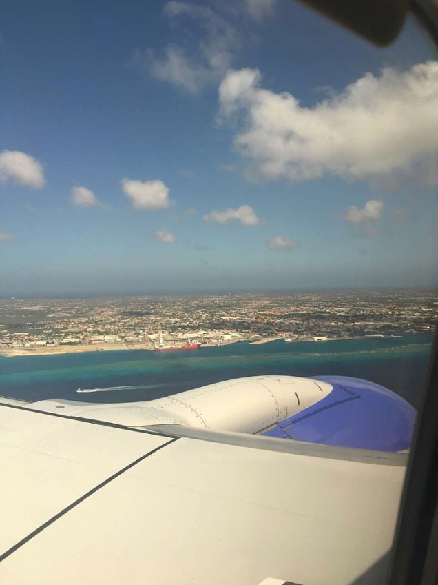 Our first view of the island


 Our first stop was the beautiful
 I was so ready to get out of that jeep..I felt like I was going to have some kind of internal injuries after that drive!

 There were goats all over the park!
 We first arrived to the Boca Prins Sand Dunes….they looked so out of place.


 We stopped and took pictures along the way to
  After being in the heat and desert like conditions all day, we were ready to cool off in the beautiful waters of
 We stayed here to watch the beautiful sunset.
 After breakfast, we headed to the

 The next stop was the
  We made a few stops along the way before we got to the church. We passed these big boulder fields along the way.
 Of course, once we spotted this big black rock that was almost perfectly round, we had to stop and take pics.
 We finally arrived to the church. I think it took us around 25-30 mins or so to get there from the Lighthouse.

 We then headed to
 We then headed to the
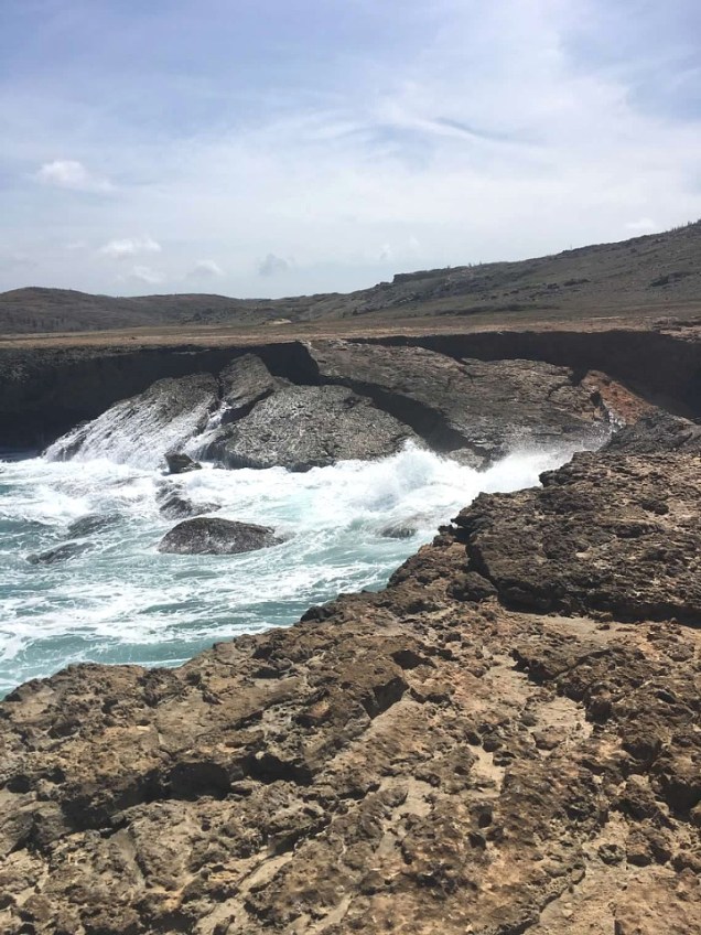 The collapsed bridge
 We then headed to the


 At the top, you get an amazing view of
  We then headed back to our hotel to get ready for dinner.

 Since the snorkeling wasn’t that good, we decided to go back to
 The next day, I had surprised my hubby with a couples massage at the
 Tip– I recommend if you book a massage that you book the earliest time available to beat the crowds that are all fighting to get their pic made with the flamingos. There was hardly anyone there when we arrived.
 They explained what we needed to do and then walked outside so we could shower off and get on the massage tables.

 This was a splurge for us because we were celebrating our 29th yr wedding anniversary but I loved it so much that I would definitely pay to do it again even if it wasn’t a special occasion!


 Read reviews
  They also sell shrimp. You have to tell them how many pounds you want of each(if you want both). The guys that took our order were good about gauging the weight based on the number of people you were ordering for.
 We sat at a table right beside the water and as we were waiting on our food, the local fishermen pulled up in their boats to drop off their catch of the day.
 Funny story…after dinner, we went to leave but then decided to walk down beside the restaurant to take a picture of the sunset. There was a house beside the restaurant that, unbeknownst to us, was the house of the restaurant owner’s sister.
 We then ended up driving to the
 We saw about 4-5 different types of birds along with a turtle. There’s an observation tower you can climb for better views but we didn’t climb it.


 We first ordered the grouper fingers and the fried funchi (similar to corn bread) with dutch cheese. The menu said it was a “must on the Aruban table” so we had to try it. Both were delicious!
 We then ordered the fish sandwich….it was so good! We both agreed that this was one, if not the best, meal we had in Aruba.
 My hubby is a burger connoisseur …he loves burgers and always researches the best place to get one anytime we go anywhere. So, during his research, he came across this place called

 Read the reviews on this restaurant

 After spending some time here, we headed out…but about that time, I told my husband that it looked like a water spout was forming. I had never seen one in person so I was really hoping that’s what was happening.
 I only had time to snap a few pictures with my iPhone before it dissipated so the quality isn’t the best.
 Goodbye Aruba..it was fun!!